Introduction to Blue Glacier
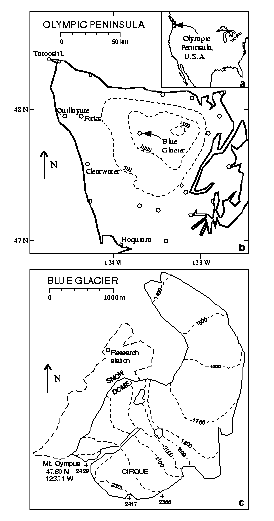
An index map of the United States is shown in the upper right corner of top figure. The top figure shows the Olympic peninsula of Washington state. Weather stations are represented by open circles and elevation contours for topography are smoothed over 12 km.
The lower figures shows Blue glacier and an adjacent glacierized region. The accumulation zones Cirque and Snow Dome are marked. This map was adapted from the 1990 U.S. Geological Survey map of the Mount Olympus quadrangle that was made from vertical photography taken August 1987. All elevations are in meters above the National Geodetic Vertical Datum of 1929.
Source: Rasmussen and others (2000, Figure 1)
Glacier Statistics:
The Duwamish Indians called the region Sun-a-do, but when the English navigator John Meares saw the snowcapped mountains from his ship in 1778, he thought they could be the home of the Gods and named the highest peak Mt Olympus.
In more recent times Blue Glacier has been the subject of studies by groups from University of Washington, California Institute of Technology, Ohio State University, US Geological Survey and US National Park Service. A copy of every publication in the linked list below is archived and can be borrowed from the University of Washington glaciology group. Current work on Blue Glacier primarily includes photographic observations of the snowline and Global Positioning System (GPS) measurements of the glacier surface.
Ben Drummond is the author of Blue Ice, a photographic and descriptive guide to Blue Glacier. This accessible work well summarizes characteristics of glaciers as exhibited through Blue Glacier.