The December 26, 2004 Sumatran
Tsunami
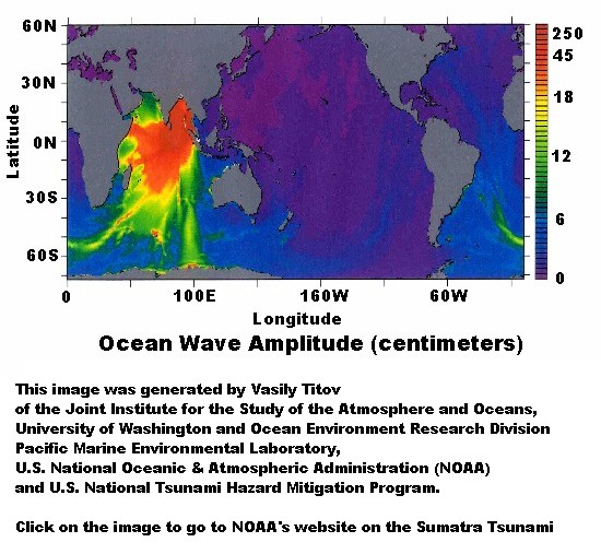 On the morning
of
December 26, 2004 a magnitude 9.3 earthquake struck off the Northwest coast
of the Indonesian
island of Sumatra. The earthquake resulted from complex
slip on the fault where the oceanic portion of the Indian
Plate slides under Sumatra, part of the Eurasian Plate. The
earthquake deformed the ocean floor, pushing the overlying water up into a tsunami
wave. The tsunami wave devastated
nearby areas where the wave may have been as high as 25 meters (80 feet) tall
and killed nearly 300,000
people from nations in the region and tourists from around the world. The
tsunami wave itself also traveled the globe, and was measured in the Pacific
and many
other places by tide gauges. Measurements in California exceeded 40 cm in
height, while New Jersey saw water level fluctuations as great as 34 cm. Eyewitness
accounts, photos,
and videos
provided unprecidented documentation of the event. To prepare for future tsunamis,
we encourage everyone to educate themselves about what they can do now,
and in the event that they
should ever be threatened by a tsunami.
On the morning
of
December 26, 2004 a magnitude 9.3 earthquake struck off the Northwest coast
of the Indonesian
island of Sumatra. The earthquake resulted from complex
slip on the fault where the oceanic portion of the Indian
Plate slides under Sumatra, part of the Eurasian Plate. The
earthquake deformed the ocean floor, pushing the overlying water up into a tsunami
wave. The tsunami wave devastated
nearby areas where the wave may have been as high as 25 meters (80 feet) tall
and killed nearly 300,000
people from nations in the region and tourists from around the world. The
tsunami wave itself also traveled the globe, and was measured in the Pacific
and many
other places by tide gauges. Measurements in California exceeded 40 cm in
height, while New Jersey saw water level fluctuations as great as 34 cm. Eyewitness
accounts, photos,
and videos
provided unprecidented documentation of the event. To prepare for future tsunamis,
we encourage everyone to educate themselves about what they can do now,
and in the event that they
should ever be threatened by a tsunami.
Other links for the Sumatra Tsunami:
http://www.drgeorgepc.com/Tsunami2004Indonesia.html
- Dr. George Pararas-Carayannis web page detailing
the Sumatra tsunami. Well presented in easily readable terms with good graphics
and illustrations. KID-FRIENDLY!
www.pmel.noaa.gov/tsunami/sumatra20041226.html-
NOAA's web link compilation of links for the Sumatra tsunami includes: Field
Survey, Sea Level, Satellite and Seismic Data, Model Simulations as well as
links for photographs and video. ww.pmel.noaa.gov/tsunami/sumatra20041226.html
Frequently
asked questions about the Sumatra Tsunami