![[Help]](/tsunami/images/help.gif)
 This simulation
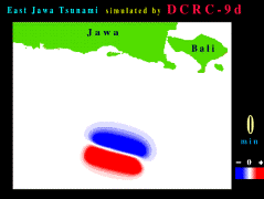
(7.7 MB) of the 1994 East Java tsunami was developed by Nobuya
Horiuchi of the Disaster Control Research Center, Tohoku University,
Japan. It shows the initial water-surface profile over the source
area and the subsequent wave propagation away from the source.
Areas in blue represent a water surface that is lower than the
mean water level, while areas in red represent an elevated water
surface.
This simulation
(7.7 MB) of the 1994 East Java tsunami was developed by Nobuya
Horiuchi of the Disaster Control Research Center, Tohoku University,
Japan. It shows the initial water-surface profile over the source
area and the subsequent wave propagation away from the source.
Areas in blue represent a water surface that is lower than the
mean water level, while areas in red represent an elevated water
surface.
![[Table of Contents]](/tsunami/images/tcarrow.gif)
![[Events]](/tsunami/images/events.gif)
![[East Java]](/tsunami/images/eastjava.gif)