Surface Elevation Variations
Recent surveys of the lower Blue glacier have been done with a Global Positioning System (GPS) to map surface elevation. Beginning in 2004 a consecutive, multi-year study of surface elevation was supported by the Evolving Earth Foundation. The University of Washington glaciology group has been involved with these efforts, led primarily by Al Rasmussen, Howard Conway, and Michelle Koutnik. Assistance with the GPS system has been provided by Tony Qamar and field work has been possible with the help of Joe MacGregor, Andy Gendaszek, Erin Whorton, and Greg Balco.
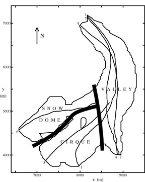
Data collected over the lower glacier in 2003 and 2004 has been compared to the 1987 map (made by the United States Geological Survey) and a study led by Keith Echelmeyer in June 1996. Five laser altimetry flights over the entire glacier have been used to make map surface elevation. The below figure shows the locations of the laser profiles. The heavy black lines show the separation of the three zones of the glacier: two accumulation zones, Snow Dome and Cirque, and the lower valley glacier.
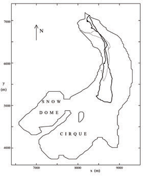
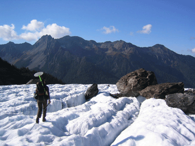
Studies done in 2003 and 2004 were done on the lower glacier by walking along the surface with the GPS system rover. The below figure shows the paths taken (lighter line shows 2003 and darker line shows 2004). The photograph shows how the GPS rover is mounted onto a backpack and used to walk around the glacier surface.
After the GPS survey, data can be compared with the 1987 map and to the past measurements of surface elevation done in 1996 (adjusted to represent October 1995). The results of this are shown below and presented as change in elevation (dZ) from 1987 to 1995, 1987 to 2003, and 1987 to 2004 over the altitude of the profile (Z). The 1995 profile is presented as an average over the three separate profiles. There are two profiles for 2004. The trend lines for the 1995 and 2003 data are overlaid on each plot.
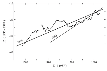
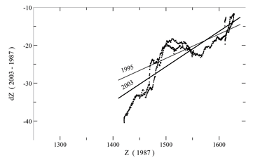
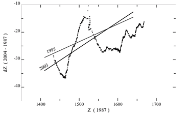
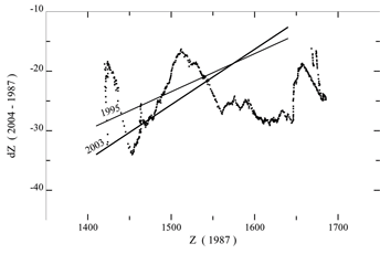
High points in each of these plots show where there has been less surface elevation lowering from the study year to 1987. Low points show where there has been the most lowering. It is interesting that the data are not linear, especially for 2004. This tells us that there are areas that are experiencing less change than other areas, we term these areas "bulges" for this discussion. It is important to note that the bulges do not appear as obvious physical features but do show up clearly in the surface elevation data.
Bulges may also be seen in the 1995 profiles, though it is likely that they are different features. The bulges seen in 2004 are up glacier from those seen in 1995. We speculate that these features may represent kinematic waves. A kinematic wave forms when more snow has fallen in the accumulation zone and then flows faster downglacier. More work will need to be done to understand if the observed bulges are actually kinematic waves. This will be further investigated in the coming field seasons.