Oct. 1, 1996 - Sept. 30, 1997
Non-technical Summary
Magnetotelluric data were collected on the Parkfield and Cholame segments of the San Andreas Fault in Central California. The goal of the survey was to image the electrical resistivity structure of the fault zone. Since the electrical resistivity in the earth is very sensitive to the presence of interconnected fluids, this is parameter can help delineate the distribution of fluids within the fault zone. Data were collected on 3 profiles in September and October 1997 and is presently being analyzed.
Broadband magnetotelluric data were collected on 3 new profiles across the San Andreas Fault in Central California between September 23 and October 29 1997. The goal of the survey was to extend the measurements made in 1994, and to see if the low electrical resistivity observed close to the 1966 hypocenter is typical of the entire Parkfield segment. Under a cooperative research program, a Department of Energy grant funded the data collection and this U.S.G.S. grant is supporting data analysis.
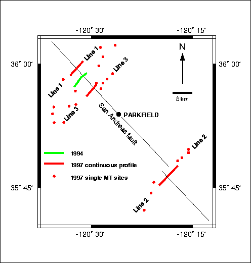
Two of the profiles crossed Middle Mountain on either side of the profile collected in 1994 and described in Unsworth et al (1997). The third profile crossed the San Andreas in the Cholame Valley, some 5 km northwest of Highway 46. Each profile consisted of continuous profile close to the fault (measurements every 100 meters) and single MT sites away from the fault zone. Data were collected using the new 24-bit magnetotelluric system developed by Electromagnetic Instruments Incorporated (EMI) of Berkeley, California. The superior dynamic range of the system enabled data to be collected beneath electric power lines without saturation of the sensitive amplifiers in the data acquisition system. A 12 channel and 5 channel instrument were simultaneously operated to provide remote reference data. Each profile was approximately 15 km long. The locations of the lines is shown in Figure 1.
Since data collection finished only 3 weeks ago, there has not been sufficient time to finish processing, modeling and interpreting the magnetotelluric data. In this section we will show the initial data pseudosections and make some comments. It should be born in mind that the data will be reprocessed and extensive modeling undertaken, so that these comments are very preliminary. For this reason only data sections, and not resistivity models are shown in the attached figures.
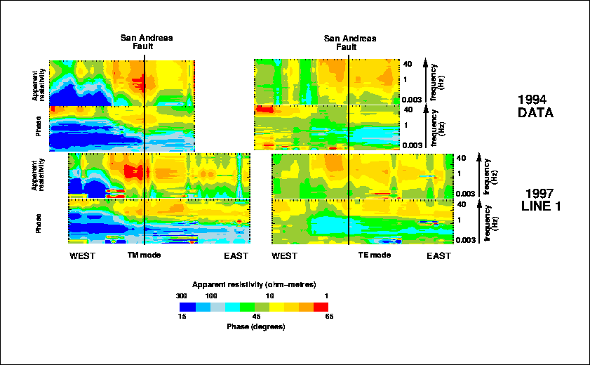
Figure 2 shows the magnetotelluric pseudosection for Line 1, located approximately 3 km northwest of the 1994 line that was described in Unsworth et al. (1997). Period is plotted on the vertical scale, and since longer periods penetrate further into the earth, this gives an impression of how electrical resistivity varies with depth. The Transverse Electric (TE) mode data is derived from electric currents flowing parallel to the San Andreas Fault, while Transverse Magnetic (TM) data is derived from electric currents crossing the fault zone. The figure shows a comparison with the data pseudosections collected in 1994. Note the striking similarity of high and low apparent resistivity and phase, indicating that the fault zone is very much a two-dimensional structure at this location. Inversion of this data yields an electrical resistivity model very similar to that on the 1994 line, with a conductive fault zone. The more symmetric coverage of the fault zone and the longer profile will enable this data set to give more reliable information about structure at depth than was previously available with the 1994 data alone.
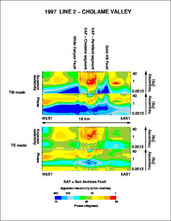
Figure 3 shows corresponding data pseudosections for Line 2 that crossed the San Andreas fault zone in the Cholame Valley. In contrast to Middle Mountain, the fault lies in a narrow valley. The profile crossed the fault just south of a right lateral 1 km en echelon offset. Note the very low resistivities associated with the valley sediments. An initial inversion shows that these sediments are approximately 1 km thick and the low resistivity zone terminates on it's western end beneath the surface trace. To the east a large change in resistivity is associated with the Gold Hill thrust fault, with relatively conductive material to the east.
Unsworth, M.J., P.E. Malin, G.D. Egbert and J.R. Booker, Internal Structure of the San Andreas fault at Parkfield, California, Geology, 25, 359-362, 1997.
Unsworth, M.J., G.D. Egbert and J.R. Booker, High resolution electromagnetic imaging of the San Andreas Fault in Central California, in review for Journal of Geophysical Research, 1997.
Unsworth, M.J., P. Bedrosian, G.D. Egbert and M. Eisel, 1997, Three-dimensional resistivity structure of the San Andreas Fault at Parkfield, California, Fall Meeting of the American Geophysical Union, San Francisco, December, 1997.