Images & website content: © EPIC. All rights reserved.
|
||||||
 |
 |
 |
 |
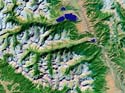 |
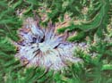
| EP_0005_JD_GL_01.jpg Mt. Rainier stratovolcano, WA. |
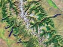
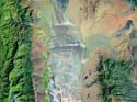
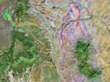
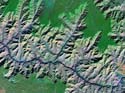
EP_0006_JD_ST_02.jpg Grand Tetons, Jackson Hole, WY. |
EP_0007_JD_GL_03.jpg Cirques and glacial troughs in the Sierra Nevada; moraines along the base of the range SW of Mono Lake, volcanic cones and glass flows south of Mono Lake, CA. |
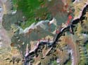
EP_0008_JD_GL_04.jpg Cirques and glacial trough of the Rocky Mts., CO; moraines enclosing Turquoise Lake (top) and Twin Lakes (bottom). |
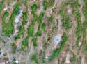
EP_0009_JD_GL_05.jpg Cirques and glacial troughs of the Rocky Mts., CO; moraines extending from the mountains into the broad valley. |
 |
 |
 |
 |
 |
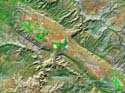
| EP_0010_JD_GL_06.jpg Cirques and glacial troughs of the Wind River Range, WY; moraines enclosing lakes at the mountain front. |
EP_0011_JD_GL_07.jpg Cirques, aretes, and horns of the Unita Mts., UT; skeletal ridges left from extensive glaciation. |
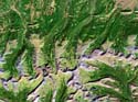
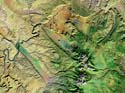
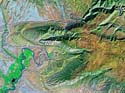
EP_0012_JD_GL_08.jpg Cirques, aretes, and glacial troughs of Glacier National Park, Northern Rocky Mts., MT; moraines enclosing lakes at the mountain front. |
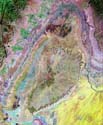
EP_0013_JD_GL_09.jpg Multiple shorelines of Pleistocene pluvial lake, Spring Valley. |
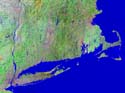
EP_0014_JD_GL_10.jpg New England. Two moraines making up Manhatten Island (lower left) extend eastward to Cape Cod. |
 |
 |
 |
 |
 |
| EP_0015_JD_FL_01.jpg Tilted fault-block ranges of the Great Basin, Death Valley region. |
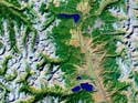
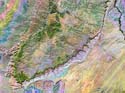
EP_0016_JD_FL_02.jpg Tilted fault-blocks of the central Great Basin and Range - CA, NV, AZ, and UT. Great Salt Lake (upper right), and Wasatch Range, UT. |
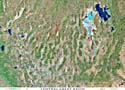
EP_0017_JD_FL_03.jpg Tilted fault blocks of the central Great Basin. |
EP_0018_JD_FL_04.jpg Tilted fault blocks of the Basin and Range, Death Valley (center). |
EP_0019_JD_FL_05.jpg Tilted fault blocks of the Basin and Range; Death Valley (center). |
 |
 |
 |
 |
 |
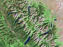
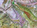
| EP_0020_JD_FL_06.jpg Glaciated Grand Teton Range, Jackson Hole, WY. Moraines enclosing Jackson Lake and Jenny Lake. |
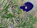
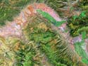
EP_0021_JD_FL_07.jpg Great Salt Lake, shorelines of ancestral Pluvial Lake Bonneville; Wasatch (along the eastern part of the basin. |
EP_0022_JD_FL_08.jpg Tilted fault blocks of the Great Basin, San Andreas fault (line across lower left), Salton Sea (bottom center), Garlock fault. |
EP_0023_JD_FL_09.jpg San Andreas fault, Point Reyes, CA. |
EP_0024_JD_FL_10.jpg San Andreas fault, Carrizo Plain (linear feature NW-SE across image). |
 |
 |
 |
 |
 |
| EP_0025_JD_FD_01.jpg Capital Reef, UT; Henry Mt. laccoliths (lower right). |
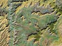
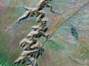
EP_0026_JD_FD_02.jpg Stream flowing across geologic structure near Cainville Reef, SW UT. |
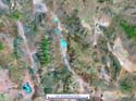
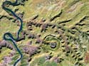
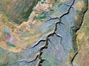
EP_0027_JD_FD_03.jpg Salt anticlines, Paradox Valley, Castle Valley, UT. |
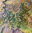
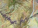
EP_0028_JD_FD_04.jpg Transverse drainage across geologic stuctures, NW of Moab, UT. |
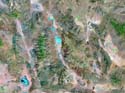
EP_0029_JD_FD_05.jpg Salt anticline, Paradox Valley, UT. |
 |
 |
 |
 |
 |
| EP_0030_JD_FD_06.jpg San Raphael Swell breached dome, UT. |
EP_0031_JD_FD_07.jpg Uncompahgre uplift, UT. |
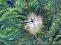
EP_0032_JD_FD_08.jpg Upheaval dome, incised meanders, UT. |
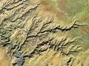
EP_0033_JD_FD_09.jpg Drainage across westward plunging anticlines, near Dinosaur National Park, UT. |
EP_0034_JD_FD_10.jpg Southern part of the San Raphael Swell breached dome, UT. |
 |
 |
 |
 |
 |
| EP_0035_JD_VO_01.jpg Mt. Hood stratovolcano, OR. |
EP_0036_JD_VO_02.jpg Mt. St. Helens, WA. |
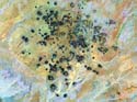
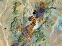
EP_0037_JD_VO_3.jpg Cinder cones and lava flows of the Big Bend volcanic field. |
EP_0038_JD_VO_04.jpg Cinder cones and lava flows of the Big Bend volcanic field. |
EP_0039_JD_VO_05.jpg Cinder cones and lava flows of the Cima volcanic field, AZ. |
 |
 |
 |
 |
 |
| EP_0040_JD_VO_06.jpg Basalt lava flows of Craters of the Moon, ID. |
EP_0041_JD_VO_07.jpg Cinder cones and lava flows of Hopi Buttes volcanic field. |
EP_0042_JD_VO_08.jpg Cinder cones and lava flows at lower Grand Canyon, AZ. |
EP_0043_JD_VO_09.jpg Cinder cones and lava flows of Lunar Crater volcanic field. |
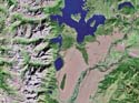
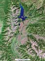
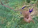
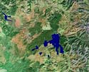
EP_0044_JD_VO_10.jpg Yellowstone caldera, Yellowstone Lake, Yellowstone National Park, WY. |
 |
 |
 |
 |
 |
| EP_0045_JD_ST_01.jpg Bright Angel, Grand Canyon, AZ. |
EP_0046_JD_ST_02.jpg Incised meanders, Canyonlands, UT. |
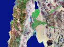
EP_0047_JD_ST_03.jpg Baja Peninsula, Colorado River delta, Salton Sea. |
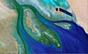
EP_0048_JD_ST_04.jpg Delta of the Colorado River. Baja, CA. |
EP_0049_JD_ST_05.jpg Incised meanders, mesas and buttes, Dirty Devil drainage, UT. |
 |
 |
 |
 |
 |
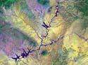
| EP_0050_JD_ST_06.jpg Incised dendritic drainage, Dirty Devil drainage, UT. |
EP_0051_JD_ST_07.jpg Incised drainage, Glen Canyon, UT. |
EP_0052_JD_ST_08.jpg Incised meanders, Comb Ridge hogback, UT. |
EP_0053_JD_ST_09.jpg Incised channel of the Colorado River, Marble Canyon, UT. |
EP_0054_JD_ST_09.jpg Incised drainage, Marble Canyon, UT. |