Images & website content: © EPIC. All rights reserved. Click thumbnails below to view larger image.
|
 |
 |
 |
 |
 |
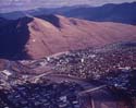
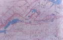
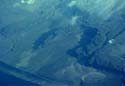
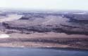
| 01.EP_0158_DR_MF_01.jpg Shorelines of glacial Lake Missoula, Missoula, MT. (D.A. Rahm) |
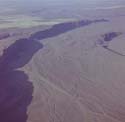
02.EP_0106_JS_MF_02.jpg Lake Missoula shorelines northeast of Camas Prairie and Wills Creek, MT. (J. Shelton) |
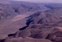
03.EP_0107_JS_MF_03.jpg Shorelines of glacial Lake Missoula, Missoula, MT. (J. Shelton) |
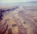
04.EP_0088_DE_MF_04.jpg Lake Missoula terraces, Missoula, MT. (D. Easterbrook) |
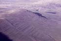
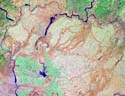
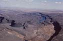
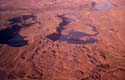
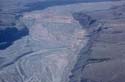
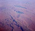
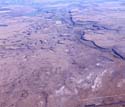
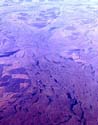
05.EP_0002_JD_MF_05.jpg Satellite photo of the channeled scablands. (J. Dohrenwend) |
 |
 |
 |
 |
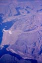 |
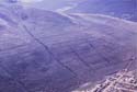
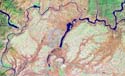
| 06.EP_0003_JD_MF_06.jpg Satellite photo of the channeled scablands. (J. Dohrenwend) |
07.EP_0019_NASA_MF_07.jpg Satellite image of Channeled Scablands, Columbia Plateau, WA. (NASA) |
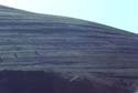
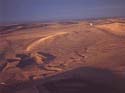
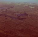
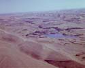
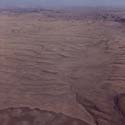
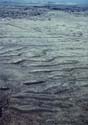
08.EP_0159_DR_MF_08.jpg Giant flood bar and ripples, Missoula flood. (D. Rahm) |
09.EP_0018_USGS_MF_09.jpg USGS topographic map of Dry Falls. (USGS) |
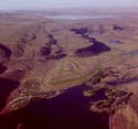
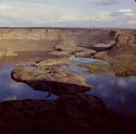
10.EP_0089_DE_MF_10.jpg Dry Falls, Grand Coulee, WA. (D. Easterbrook) |
 |
 |
 |
 |
 |
| 11.EP_0160_DR_MF_11.jpg Dry Falls, Grand Coulee, WA. (D. Rahm) |
12.EP_0161_DR_MF_12.jpg Dry Falls, Grand Coulee, WA. (D. Rahm) |
13.EP_0162_DR_MF_13.jpg Dry Falls, Grand Coulee, WA. (D. Rahm) |
14.EP_0163_DR_MF_14.jpg Dry Falls, Grand Coulee, WA. (D. Rahm) |
15.EP_0164_DR_MF_15.jpg Dry Falls, Grand Coulee, WA. (D. Rahm) |
 |
 |
 |
 |
 |
| 16.EP_0165_DR_MF_16.jpg Dry Falls, Grand Coulee, WA. (D. Rahm) |
17.EP_0166_DR_MF_17.jpg Dry Falls, Grand Coulee, WA. (D. Rahm) |
18.EP_0167_DR_MF_18.jpg Dry Falls, Grand Coulee, WA. (D. Rahm) |
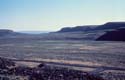
19.EP_0090_DE_MF_19.jpg Moses Coulee, WA. (D. Easterbrook) |
20.EP_0168_DR_MF_20.jpg Ice sheet moraine draped across a giant bar, Moses Coulee, WA. (D. Rahm) |
 |
 |
 |
 |
 |
| 21.EP_0091_DE_MF_21.jpg Frenchman Spurs cataract. (D. Easterbrook) |
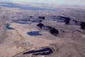
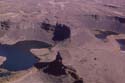
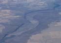
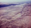
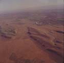
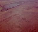
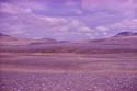
22.EP_0092_DE_MF_22.jpg Moses Lake area. (D. Easterbrook) |
23.EP_0169_DR_MF_23.jpg Moraine draped across a giant flood bar and braided stream pattern on outwash terrace. (D.A. Rahm) |
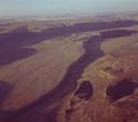
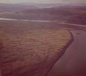
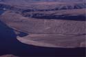
24.EP_0170_JS_MF_24.jpg Lower Moses coulee, WA. (D.A. Rahm) |
25.EP_0171_DR_MF_25.jpg Moses Coulee, WA. (D.A. Rahm) |
 |
 |
 |
 |
 |
| 26.EP_0172_DR_MF_26.jpg Moses Coulee, WA. (D.A. Rahm) |
27.EP_0093_DE_MF_27.jpg Giant bar, Moses Coulee, WA. (D. Easterbrook) |
28.EP_0173_DR_MF_28.jpg Giant bar Moses Coulee, WA. (D. Rahm) |
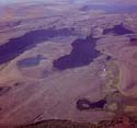
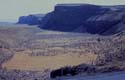
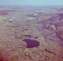
29.EP_0094_DE_MF_29.jpg Giant bar behind bedrock spur, Moses Coulee, WA. The depression behind the bar is in the lee of the bedrock spur. (D. Easterbrook) |
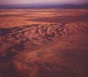
30.EP_0174_DR_MF_30.jpg Scabland channels, Columbia Plateau, WA. (D.A. Rahm) |
 |
 |
 |
 |
 |
| 31.EP_0175_DR_MF_31.jpg Abandoned falls and scabland channels, Columbia Plateau, WA. (D.A. Rahm) |
32.EP_0176_DR_MF_32.jpg Cheney-Palouse scabland tract, WA. (D.A. Rahm) |
33.EP_0177_DR_MF_33.jpg Scabland channels in loess, Columbia Plateau, WA. (D. Rahm) |
34.EP_0178_DR_MF_34.jpg Cheney-Palouse scabland channel, WA. (D.A. Rahm) |
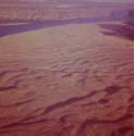
35.EP_0179_DR_MF_35.jpg Drumheller channels, Columbia Plateau, WA. (D.A. Rahm) |
 |
 |
 |
 |
 |
| 36.EP_0180_DR_MF_36.jpg Scabland channel, Columbia Plateau, WA. (D.A. Rahm) |
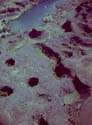
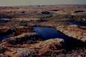
37.EP_0181_DR_MF_37.jpg Potholes, Channeled Scabland, WA. (D.A. Rahm) |
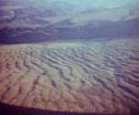
38.EP_0182_DR_MF_38.jpg Giant ripples from Missoula flood, Crescent Bar, WA. (D.A. Rahm) |
39.EP_0095_DE_MF_39.jpg Scabland south of Wenatchee. (D. Easterbrook) |
40.EP_0096_DE_MF_40.jpg Drumheller channels, WA. (D. Easterbrook) |
 |
 |
 |
 |
 |
| 41.EP_0108_JS_MF_41.jpg Giant ripples from Missoula flood, Columbia River near Wenatchee, WA. (J. Shelton) |
42.EP_0183_DR_MF_42.jpg Giant ripples from Missoula flood, Columbia Plateau, WA. (D.A. Rahm) |
43.EP_0184_DR_MF_43.jpg Giant ripples near LaCrosse, WA. (D.A. Rahm) |
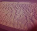
44.EP_0185_DR_MF_44.jpg Giant ripples from Missoula flood. (D. Rahm) |
45.EP_0186_DR_MF_45.jpg Giant ripples from Missoula flood, near Wenatchee, WA. (D.A. Rahm) |
 |
 |
 |
 |
 |
| 46.EP_0187_DR_MF_46.jpg Giant ripples, Columbia Plateau, WA. (D.A. Rahm) |
47.EP_0188_DR_MF_47.jpg Giant ripples from Missoula flood, Columbia Plateau, WA. (D.A. Rahm) |
48.EP_0189_DR_MF_48.jpg Giant ripples near La Crosse, WA. (D.A. Rahm) |
49.EP_0097_DE_MF_49.jpg Giant ripple marks, Plains MT. (D. Easterbrook) |
50.EP_0098_DE_MF_50.jpg Giant ripples composed of cobble gravel, near Wash-Idaho border. (D. Easterbrook) |