Images & website content: © EPIC. All rights reserved. Click thumbnails below to view larger image.
|
 |
 |
 |
 |
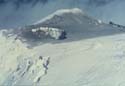 |
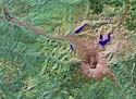
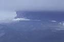
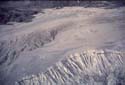
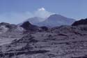
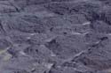
| 01.EP_0065_JD_HE_01.jpg Satellite image of Mt. St. Helens. Tan area north of the crater is the area devastated by the explosion of May 18, 1980. (J. Dohrenwend) |
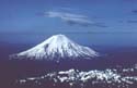
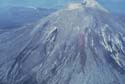
02.EP_0099_DE_HE_02.jpg Mt. St. Helens before the May 18 eruption. (D.J. Easterbrook) |
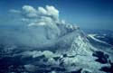
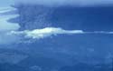
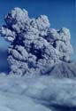
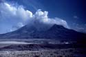
03.EP_0100_DE_HE_03.jpg Mt. St. Helens eruption of steam and ash prior to the explosion of May 18, 1980. (D.J. Easterbrook) |
04.EP_0101_DE_HE_04.jpg Mt. St. Helens eruption of steam and ash prior to the explosion of May 18, 1980. (D.J. Easterbrook) |
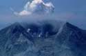
05.EP_0102_DE_HE_05.jpg Mt. St. Helens ash-covered summit and crater prior to the explosion of May 18, 1980. (D.J. Easterbrook) |
 |
 |
 |
 |
 |
| 06.EP_0103_DE_HE_06.jpg Mt. St. Helens half an hour prior to the explosion of May 18, 1980. (D.J. Easterbrook) |
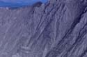
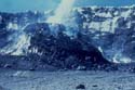
07.EP_01XX_DE_HE_07.jpg Collapsing summit crater of Mt. St. Helens prior to the explosion of May 18, 1980. The area in the lower right corner had bulged outward more than 100 m. ((D.J. Easterbrook) |
08.EP_0020_NASA_HE_08.jpg Satellite image of Mt. St. Helens. Light color is the area devastated by the explosion of May 18, 1980. Yellow is the area in which forests were killed but not removed by the May 18, 1980 explosion. Red area consists of living trees. (NASA) |
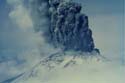
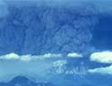
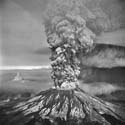
09.EP_0104_DE_HE_09.jpg Mt. St. Helens eruption of May 18, 1980. The black area on the right is ash downwind from the crater. (D.J. Easterbrook) |
10.EP_0105_DE_HE_10.jpg Mt. St. Helens eruption of May 18, 1980. The black area on the right is ash downwind from the crater. (D.J. Easterbrook) |
 |
 |
 |
 |
 |
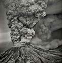
| 11.EP_0106_DE_HE_11.jpg Mt. St. Helens eruption of May 18, 1980. (D.J. Easterbrook) |
12.EP_01XX_AP_HE_12.jpg Mt. St. Helens eruption of May 18, 1980. (A. Post) |
13.EP_01XX_AP_HE_13.jpg Mt. St. Helens eruption of May 18, 1980. (A. Post) |
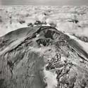
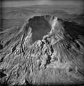
14.EP_01XX_AP_HE_14.jpg Mt. St. Helens crater after the May 18, 1980 explosion. (A. Post) |
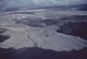
15.EP_0107_DE_HE_15.jpg Pyroclastic flows issuing from the post-May 18, 1980 crater. (USGS) |
 |
 |
 |
 |
 |
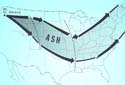
| 16.EP_0108_DE_HE_16.jpg Ash fallout pattern from the May 18, 1980 explosion of Mt. St. Helens. (D. Easterbrook/D. Pevear) |
17.EP_0109_DE_HE_17.jpg Cleaning up ash from the May 18, 1980 explosion of Mt. St. Helens. (D. Easterbrook/D. Peavear) |
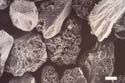
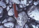
18.EP_0110_DE_HE_18.jpg Electron microscopy image of ash from Mt. St. Helens eruption. (D. Pevear) |
19.EP_0111_DE_HE_19.jpg Blast zone across the Toutle River valley from Mt. St. Helens. (D.J. Easterbrook) |
20.EP_0112_DE_HE_20.jpg Blast zone across the Toutle River valley from Mt. St. Helens. (D.J. Easterbrook) |
 |
 |
 |
 |
 |
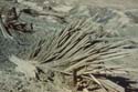
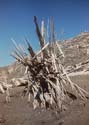
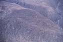
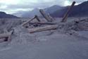
| 21.EP_0113_DE_HE_21.jpg Remains of trees shredded by the May 18, 1980 explosion of Mt. St. Helens. (D.J. Easterbrook) |
22.EP_0114_DE_HE_22.jpg Remains of trees shredded by the May 18, 1980 explosion of Mt. St. Helens. (D.J. Easterbrook) |
23.EP_0115_DE_HE_23.jpg Remains of trees shredded by the May 18, 1980 explosion of Mt. St. Helens. (D.J. Easterbrook) |
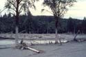
24.EP_0116_DE_HE_24.jpg Trees blown down by the May 18, 1980 explosion of Mt. St. Helens. (D.J. Easterbrook) |
25.EP_0117_DE_HE_25.jpg Trees blown down by the May 18, 1980 explosion of Mt. St. Helens. (D.J. Easterbrook) |
 |
 |
 |
 |
 |
| 26.EP_0118_DE_HE_26.jpg Trees blown down by the May 18, 1980 explosion of Mt. St. Helens. (D.J. Easterbrook) |
27.EP_0119_DE_HE_27.jpg Trees blown down by the May 18, 1980 explosion of Mt. St. Helens. (D.J. Easterbrook) |
28.EP_0120_DE_HE_28.jpg Trees blown down by the May 18, 1980 explosion of Mt. St. Helens. (D.J. Easterbrook) |
29.EP_0121_DE_HE_29.jpg Mudflow levee and valley fill in the Toutle River valley. Trees blown down by the May 18, 1980 explosion of Mt. St. Helens. (D.J. Easterbrook) |
30.EP_0122_DE_HE_30.jpg Mt. St. Helens crater after the May 18, 1980 explosion. (D.J. Easterbrook) |
 |
 |
 |
 |
 |
| 31.EP_0123_DE_HE_31.jpg Mt. St. Helens crater after the May 18, 1980 explosion. Beginning of the building of post-eruption dome. (D.J. Easterbrook) |
32.EP_0021_USGS_HE_32.jpg Post-eruption dome in Mt. St. Helens crater after the May 18, 1980 explosion. (USGS) |
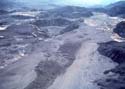
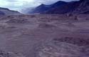
33.EP_0124_DE_HE_33.jpg Pyroclastic flows from Mt. St. Helens 1980 eruption in the upper Toutle River valley. (D.J. Easterbrook) |
34.EP_0125_DE_HE_34.jpg Pyroclastic flows from Mt. St. Helens 1980 eruption in the upper Toutle River valley. (D.J. Easterbrook) |
35.EP_0126_DE_HE_35.jpg Pyroclastic flows from Mt. St. Helens 1980 eruption in the upper Toutle River valley. (D.J. Easterbrook) |
 |
 |
 |
 |
 |
| 36.EP_0127_DE_HE_36.jpg Pyroclastic flows from Mt. St. Helens 1980 eruption in the upper Toutle River valley. (D.J. Easterbrook) |
37.EP_0128_DE_HE_37.jpg Pumice making up a pyroclastic flow from Mt. St. Helens 1980 eruption in the upper Toutle River valley. (D.J. Easterbrook) |
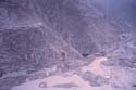
38.EP_0129_DE_HE_38.jpg Lahars from Mt. St. Helens in the Toutle River valley. (D.J. Easterbrook) |
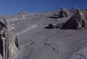
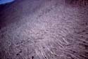
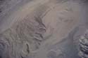
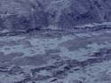
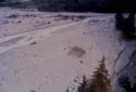
39.EP_0130_DE_HE_39.jpg Irregular surface of lahars from Mt. St. Helens in the upper Toutle River valley. (D.J. Easterbrook) |
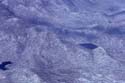
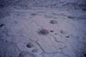
40.EP_0131_DE_HE_40.jpg Depressions in Toutle Valley lahar from Mt. St. Helens. (D.J. Easterbrook) |
 |
 |
 |
 |
 |
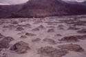
| 41.EP_0132_DE_HE_41.jpg Lahars from Mt. St. Helens 1980 eruption filling the upper Toutle River valley. (D.J. Easterbrook) |
42.EP_0133_DE_HE_42.jpg Lahars from Mt. St. Helens 1980 eruption filling the upper Toutle River valley. (D.J. Easterbrook) |
43.EP_0134_DE_HE_43.jpg Trees in lahars from Mt. St. Helens 1980 eruption filling the upper Toutle River valley. (D.J. Easterbrook) |
44.EP_0135_DE_HE_44.jpg Irregular surface of a lahar from Mt. St. Helens 1980 eruption filling the upper Toutle River valley. The lighter-toned material between mounds consists of later, more fluid mudflows. (D.J. Easterbrook) |
45.EP_0136_DE_HE_45.jpg Lahars from Mt. St. Helens 1980 eruption filling the upper Toutle River valley. (D.J. Easterbrook) |
 |
 |
 |
 |
 |
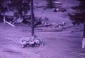
| 46.EP_0137_DE_HE_46.jpg Remains of a truck wrapped around a tree by mudflows from the Mt. St. Helens 1980 eruption, lower Toutle River valley. (D.J. Easterbrook) |
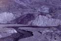
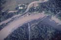
47.EP_0138_DE_HE_47.jpg Bridge taken out by mudflows from Mt. St. Helens 1980 eruption, Toutle River valley. (D.J. Easterbrook) |
48.EP_0139_DE_HE_48.jpg Remains of a bridge taken out by mudflows from Mt. St. Helens 1980 eruption, Toutle River valley. (D.J. Easterbrook) |
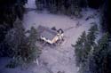
49.EP_0140_DE_HE_49.jpg Portion of a house ripped off by mudflows from Mt. St. Helens 1980 eruption, Toutle River valley. (D.Easterbrook/D. Pevear) |
50.EP_0141_DE_HE_50.jpg Mud lines on trees from mudflows of the Mt. St. Helens 1980 eruption, Toutle River valley. (D.J. Easterbrook) |