The
Seattle Fault zone includes several fault strands within a 4 to 7
km-wide (2.5
to 4 miles) east-trending band extending from the Cascade Range
foothills on
the east across the Puget Lowland to Hood Canal, crossing Lake
Sammamish, Lake
Washington, Puget Sound, Bainbridge Island, and the Kitsap Peninsula.
Most of
the evidence of these faults lies hidden beneath the major population
centers
of Seattle, Bellevue, and Bremerton. The most recent and largest known
earthquake within the Seattle Fault zone occurred about 1050-1020 ago,
with a
magnitude greater than M7 (Bucknam and others, 1992; Atwater, 1999;
Nelson and
others, 2000). While perhaps the most well studied crustal fault zone
in the
Puget Sound region, new information and ideas about the locations,
orientations, and history of motions of the Seattle Fault zone continue
to
emerge.All the available information
indicates that there is about a 5% chance of having a M>6.5
earthquake on one of the strands of the Seattle Fault zone in a 50 year
timeframe.Any moderate or large
earthquake on the Seattle Fault zone will likely be followed by
numerous felt
aftershocks, some that could be damaging, and hundreds to thousands of
smaller
ones detectable only by sensitive instruments.
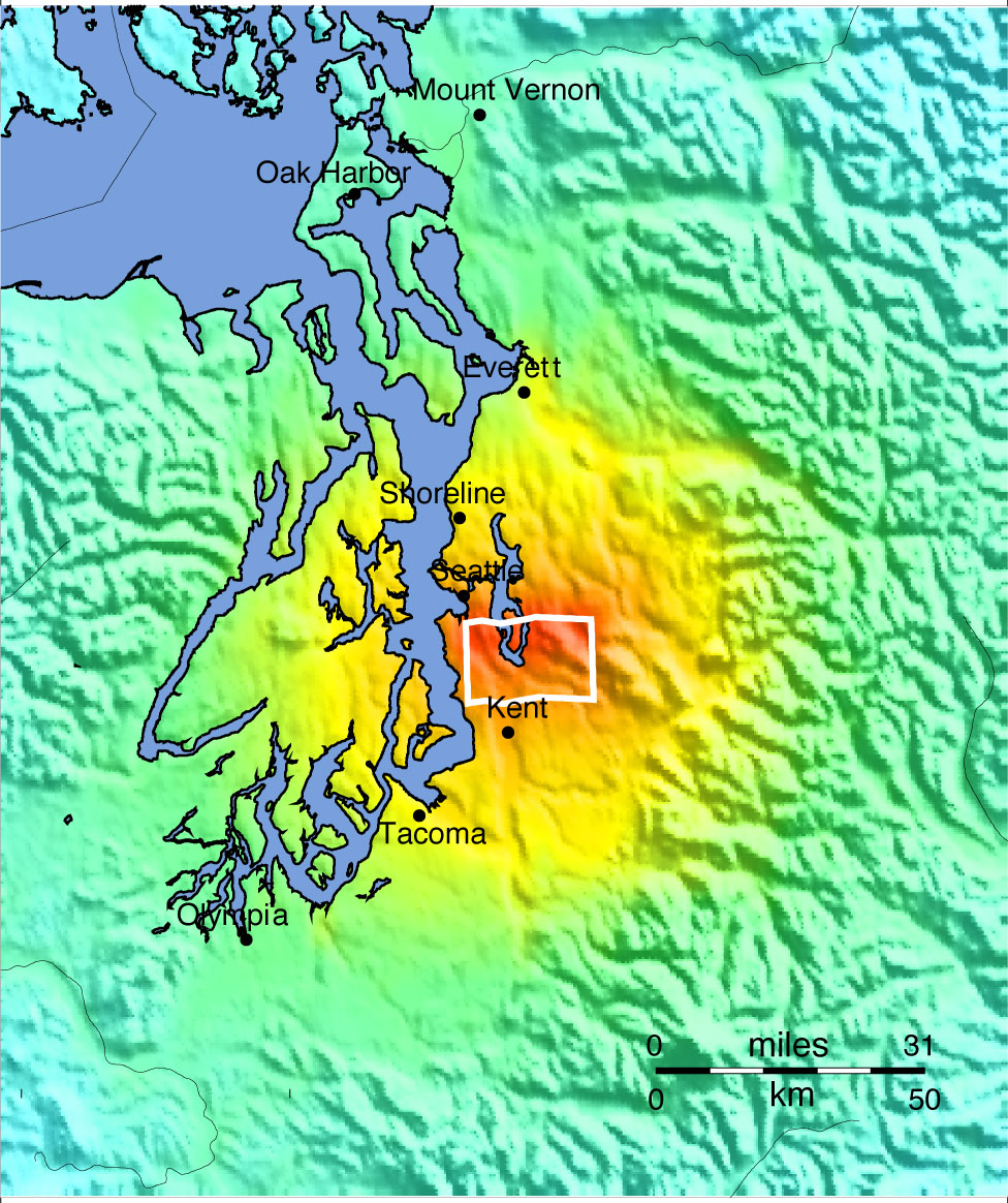
‘ShakeMap’
showing
the
intensity
of
ground
shaking
(colors)
expected
for
a M6.7
earthquake on a fault within the Seattle Fault zone (causative fault
outlined in white), overlain on topograp
A M6.7 earthquake, like that assumed in
the Evergreen Exercise Series (see ShakeMap on left), thousands of
years ago on the northernmost strand of the Seattle Fault Zone might be
what caused surface displacement of about 6.5 feet mapped just west of
Lake Sammamish in southeast Bellevue, near Southeast 38th Street.The causative fault rupture extends for about
23 km (14 mile), from Harbor Island to just east of Lake Sammamish.
These same characteristics were used to as the basis for this
earthquake scenario.The starting point of
the scenario is a model of the ground shaking, displayed as ShakeMap
(left).
The Seattle fault was originally
identified by abrupt changes in measurements of the Earth’s gravity
field, caused by the juxtaposition of rocks of contrasting densities
(Danes et al., 1965).Fault slippage
during an earthquake uplifted older volcanic rocks of Tertiary age
(65-2.6 million year old) on the south side of the fault and
down-dropped younger sediments to the north. More recently additional,
parallel fault strands were identified within an east-trending zone,
evident in a variety of
geophysical
measurements (Blakely et al., 2000).
The
Seattle Fault Zone has hosted multiple larger earthquakes. The clearest
evidence of one of these can been seen in a conspicuous flat surface,
or
platform, bordering the shoreline of southern Bainbridge Island, parts
of
Kitsap County, and Alki Point in West Seattle. This platform initially
formed
as wave action cut the surface while at a lower, intertidal elevation.About 1100 years ago a single earthquake
uplifted this surface as much as 8 meters (Bucknum et al., 1992), and
caused a
tsunami, liquefaction, and landslides.Examination of the geologic record extending as far back as 8000
years
ago reveals evidence for another comparable sized earthquake on the
Seattle
Fault Zone about 6900 years ago (Sherrod et al., 2000), suggesting a
recurrence
interval on the order of thousands of years. More recent studies of
newly
identified fault scarps (scars on the surface left when faulting cuts
the
Earth’s surface) within the Seattle Fault Zone confirmed these
inferences.Analyses of high-resolution
topographic
imagery (LiDAR), followed-up on with trenching studies, led to the
discovery of
a fault scarp on southern Bainbridge Island that probably formed in as
many as
three surface-rupturing earthquakes in the past 2500 years (Nelson at
all,
2003, 2003).Additional LiDAR and
trenching studies identified fault scarps at Islandwood on Bainbridge
Island,
Waterman Point and Point Glover in Kitsap County, which probably formed
as a
result of two surface-rupturing earthquakes about 1100 years ago
(Nelson et al,
2003).
Some of the impacts of a
M6.7 Seattle Fault zone earthquake have been quantified using the HAZUS
program.Because this is a moderate
earthquake, the serious damage will result in places and the financial
cost of
recovery very significant. Example impacts estimated by the HAZUS
program
include about 7% (96,412) of inventoried buildings at least moderately
damaged (i.e., have a 50%
chance of
being functional) and ~3% of these
damaged beyond repair. One week after the earthquake, 90% of the
9,008
hospital beds in use on the day of the earthquake will be back in
service and
after 30 days 99% will be operational. No critical facilities,
transportation
systems or lifelines will be completely destroyed. Schools will
experience the
greatest damage among critical facilities, with ~13% experiencing
moderate or
greater damage. Among the transportation networks and utilities that
have
moderate or greater damage are ~2% of the bridges and 15% of the port
facilities, and 35% of communications and 31% of potable water systems.
5% and
11% of households will be without potable water and electricity,
respectively,
in the first day after the earthquake, but after a week these
percentages will
both have dropped to 3%. 166,920 truckloads of debris will need to be
removed.12,771 households will be
displaced with 57% of these requiring temporary sheltering.Between 68 to 345 fatalities are forecast,
depending on the time of day the earthquake strikes. The total
building-related
losses are estimated to cost 15 billion dollars.
Darrington-Devils
Mountain fault zone M5.7 Earthquake Scenario
Darrington
– Devils Mountain Fault Zone (DDMFZ) extends westward for more than 125
km (77
miles) from the Cascade Range foothills to offshore Vancouver Island.
It was
initially identified as two separate fault zones; at its east end the
Devils
Mountain fault merges with the Darrington fault zone (Tabor, 1994) and
at its
west end, the Devils Mountain fault may merge with the Leech River and
(or) San
Juan faults on Vancouver Island (Johnson and others, 2001). Any
moderate or
large earthquake on the DDMFZ will likely be followed by numerous felt
aftershocks and hundreds to thousands of smaller ones detectable only
by
sensitive instruments.
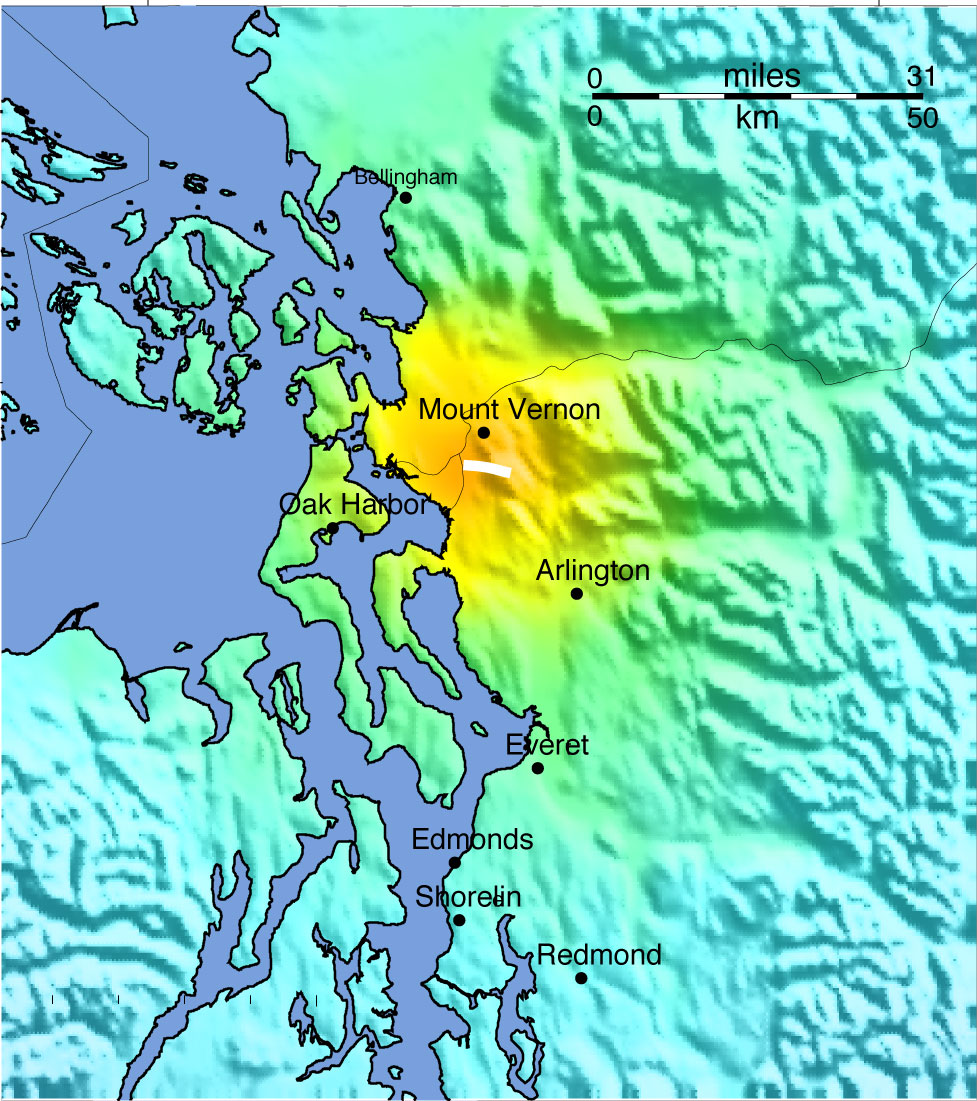
‘ShakeMap’ showing the
intensity of ground shaking (colors) expected for a M5.7 earthquake on
a segment of the Darrington –Devils Mtn fault (white line indicates
intersection of the causative fault with the surface), overlain on
topography.
The
M5.7
earthquake
scenario
for
the
DDMFZ
assumes a 5-10 km (3-6 mile) long section of fault ruptures between Mt.
Vernon and Darrington (see ShakeMap on right).The
DDMFZ
forms
the
northern
boundary
of
the
sediment-filled,
Everett
basin.This
boundary
separates rocks with differing
magnetic properties and thus can be ‘seen’ as changes in the magnetic
field measured over the area that occur in a linear band extending from
the Cascade Mountains to Vancouver Island, British Colombia (Johnson et
al. 2001). This juxtaposition of rocks with different magnetic
signatures likely resulted from slippage along a fault surface.
The Darrington – Devils Mountain fault
zone was initially identified and named independently by two different
geologists, who both noted contrasting rock types and ages juxtaposed
along northeast trending faults.Separate
exposures on Devils Mountain near Mt. Vernon, Washington (Loveseth,
1975) and near the town of Darrington (Vance et al., 1980) were named
accordingly, but later recognized as the same fault zone and the names
merged (Tabor, 1994).
High-resolution
LiDAR topographic maps have since revealed several potential faults
scarps, and
subsequent studies provide more detailed information about the fault
zone’s
past. Trenches across scarps on Whidbey Island exposed faulted and
folded
glacial sediments, and mapping of these indicate the causative fault
strands
slipped in a variety of directions, with total offsets of~1.0-4.5 m (3.1 to 14.8 feet) vertically and
~2 m (6 feet) horizontally (Johnson et al., 2004). Radiocarbon ages
from these
trenches show that these offsets likely resulted from two earthquakes,
one
~1100-2200 years ago and the second earthquake 100-500 years ago
(Johnson et
al., 2004).Other strands underlie a low
scarp (< 1 m tall) in Skagit County east of Mount Vernon, and three
trenches
across this scarp exposed faulted glacial deposits and sheared bedrock,
with
similar complexity and vertical offsets of ~0.5 m (1.6 feet)
(Personious et al.
2009) and horizontal displacements between 1-3.5 m (3.3-9.8 feet)
(Personious
et al., 2009).
The impacts of this earthquake are
forecasted to be quite mild, in part because of its location remote
from large
population centers.Example impacts
quantified using the HAZUS program indicate that about 1,468 buildings
will be
at least moderately damaged (50%
chance
of
being
functional)
and only 2
buildings that will be damaged beyond repair. However
building-related losses may be as much as $165 million dollars. 99% of
the
impacted regions 11,301 hospital beds will be available for use within
a day
after the earthquake and 100% within a week.No critical facilities or transportation systems will experience
even
moderate damage.Some pipelines (<1%)
may break and 2,362 households will be without potable water the first
day,
although all will have it restored within a week.None
should
experience
loss
of
electricity.
27
households
could
be
displaced.
No fatalities and only a few serious
injuries
are expected. 1,160 truckloads of debris will require removal.
SOUTHERN WHIDBEY ISLAND FAULT M7.4 EARTHQUAKE
SCENARIO
Much
of the Southern Whidbey Island fault zone (SWIF), which runs in a
north-westward
direction from Woodinville to near Port Townsend, Washington, remains
mostly
hidden. Geologists conclude that the SWIF is capable of producing a
M6.5 to
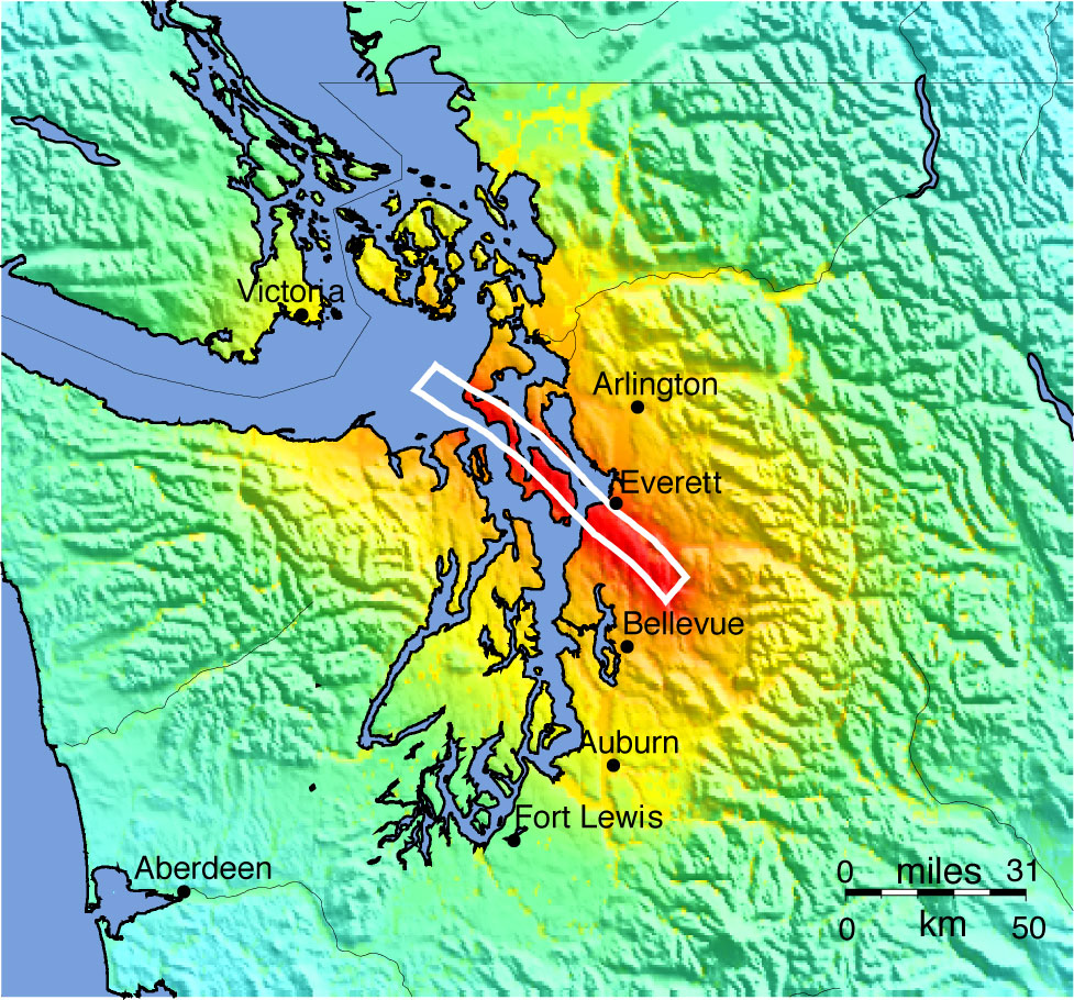
M7.4 earthquake (Kelsey et al., 2004).The ground shaking expected for a M7.4 earthquake is shown in
the
ShakeMap below. As with other crustal faults, any moderate or large
earthquake
on the SWIF will likely be followed by numerous felt aftershocks, some
that
could be damaging, and hundreds to thousands of smaller ones detectable
only by
sensitive instruments.
‘ShakeMap’ showing the
intensity of ground shaking (colors) expected for a M7.4 earthquake on
a segment of the South Whidbey Island fault (white line indicates
intersection of the causative fault with the surface), overlain on
topography.
The SWIF was first discovered because
movements along it juxtaposed older crystalline bedrock next to younger
volcanic basalts (Johnson et al., 1996). These rocks have contrasting
densities and magnetic properties that were measured and mapped by
Gower et al. (1985), and attributed to motions along a single fault.
Subsequent studies showed that numerous fault strands comprise the
SWIF, located within a 6-11 km (3.7-6.8 mile) wide band.
These faults dip steeply to the
northeast
and have had north-side-up and lateral displacements, and are visible
at the Earth’s surface only about every 35 km (22 miles).These studies
used seismic reflection data, sea cliff exposures, and sparse borehole
data to map the SWIF to the eastern Strait of Juan de Fuca (Johnson et
al., 1996), while others used seismic imaging methods to steer the
fault along the northwestern margin of the Port Townsend basin, where
it may merge with the Darrington-Devils Mountain fault zone near
Victoria, British Columbia (Broker at Al, 2005; Ramachandran et al.,
2005). If these
interpretations are correct, the
SWIF
extends a minimum of 150 km (92 miles) from Victoria, British Colombia,
to near
Woodinville, Washington.
Evidence
that the SWIF has been recently active comes from high-resolution
seismic images
and measurements documenting uplift of the shorelines that straddle the
faults,
along two coastal marshes on Whidbey Island, at Hancock Lake on the
south side
of the SWIF and Crockett Lake on the north side (Kelsey et al., 2004).
If no
movement on the fault strand occurred in the latter part of the last
10,000
years (Holocene epoch) both sites should have comparable sea-level
histories.
However, stratigraphic observations and radiocarbon dates used to
construct
relative sea level curves for each site diverge between 2800 and 3200
years
ago, suggesting uplift of about 1 to 2 m (3.3 to 6.6 feet) along the
north side
of the fault strand. This amount of uplift was likely generated by a
M6.5 to
M7.0 earthquake, according to empirical relationships between vertical
displacement versus magnitude for historical earthquakes (Kelsey et
al., 2004).
Earthquakes
on the SWIF probably caused at least three episodes of strong ground
shaking
and one tsunami in the last 1200 years. Geologists studied the
stratigraphy of
channel bank exposures along the Snohomish River near Everett,
Washington
reveal and infer that a widespread pairing of sand overlain by clay
that
correlates over 20 km2 was left behind by a tsunami surge
across the
delta between 1200 - 1020 years ago (Bourgeois and Johnson, 2001).
Multiple
episodes of strong ground shaking also have been inferred from
liquefaction
features, sand dikes and sand-filled cracks up to 1 m (3.3 feet) wide,
some of
which terminate below and others that cut across the tsunami deposit
and thus,
pre- and post-date it (Bourgeois and Johnson, 2001).
More
recently studies extend the record farther back in time and southward.These suggest that the SWIF produced at least
four earthquakes since deglaciation about 16,000 years ago, the most
recent
being less than 2700 years ago. High-resolution topography (LiDAR) and
measurements of the magnetic properties of the rocks reveal lineaments
indicative of fault movements.These
show that the SWIF forms a 20 km (12 miles) wide swath of parallel
fault
strands, that project onto the mainland near Everett and continues to
the
southeast towards Woodinville (Blakely et al., 2004; Sherrod et al.
2008).The most prominent feature, the
Cottage Lake
lineament, extends at least 18 km (11 miles) and lies on strike with
the SWIF
on Whidbey Island. Excavations across visible scarps that exhibit
north-side-up
vertical relief of 1-5 m (3.3 to 16.4 feet) show these were created in
multiple
earthquakes that post-date deglaciation.
Although
highly speculative, geologists have suggested that the SWIF is part of
a larger
system of faults that extends from Victoria, reddish Columbia to
Hanford,
Washington a distance of about 385 km (236 miles). However, while such
a system
may reflect very large-scale geologic processes, no evidence exists
indicating
multiple zones have failed together in a single earthquake. A series of
faults
and folds in the Snoqualmie area of the Cascades likely correlate with
the SWIF
(Dragovich et al., 2007, 2008), merge with mapped faults on Rattlesnake
Mountain (mapped by Tabor et al., 2000) near North Bend and continue
southeast
into the Cascade Mountains. Others suggest that faults in the Yakima
fold and
thrust belt correlate with faults west of the Cascades, based on
lineaments in
magnetic measurements and other observations (Blakely et al., 2009).
The
HAZUS program provides quantitative estimates of some of the impacts of
a M7.4
earthquake on the SWIF.Examples include
~97800 buildings (~5% of the inventory) at least moderately damaged,
with 6% of
these damaged beyond repair.A handful
of bridges will be destroyed completely, significant fractions of the
utility
system will be only partially functional in the first day after the
earthquake
but mostly fixed within a week.However,
in excess of 100,000 households will be without potable water or power
in the
first day and tens of thousands still without both after a week.Almost 14,000 households will be displaced
and 58% of these will require public sheltering.Fatality
estimate
range
from
90
to
432
depending
on
the
time
of day the earthquake strikes.Economic losses will be in the range of many
billions of dollars.
TACOMA FAULT ZONE M7.1 EARTHQUAKE SCENARIO
Local and regional
experts have
identified several strands of the Tacoma Fault Zone in the southern
Puget Sound
region, although the eastern extent of the zone remains uncertain.
Changes in
elevations of coastal marshes surrounding the Tacoma Fault Zone
document a
large, ~M7 earthquake that occurred on the fault about 1,100 years ago.
Studies
are underway to identify evidence of earlier quakes and to more
accurately
describe the fault system.
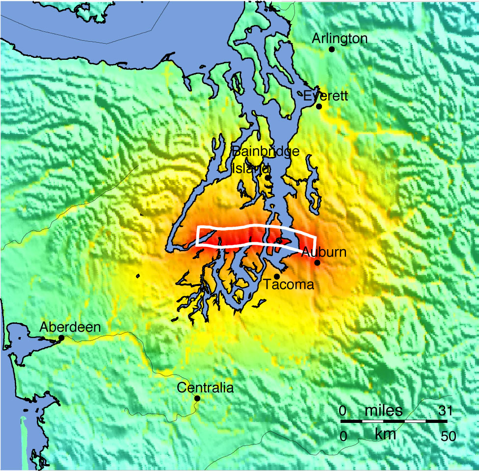
‘ShakeMap’
showing
the
intensity
of
ground
shaking
(colors)
expected
for
a M7.1
earthquake on a segment of the Tacoma fault (white line indicates
intersection of the causative fault with the surface), overlain on
topography.
The M7.1 earthquake scenario for the
Tacoma fault zone is based on a 56 km (34 miles) long rupture running
between Kent and Union, Washington (ShakeMap on right). A M7.1
earthquake within the Tacoma Fault zone will likely be followed by
numerous felt aftershocks, some that could be damaging, and hundreds to
thousands of smaller ones detectable only by sensitive instruments.
Evidence for the Tacoma fault zone
consists of several linear features (lineaments) observed in a variety
of measurements, that appear to bound a geologic structure called the
‘Seattle uplift’ along its southern and western flanks. The Seattle
uplift is a region where volcanic rocks (basalts) laid down flat about 56 to 34 million years ago and buried, have been uplifted
by as much as 6-7 km (3.7 to 4.3 miles). Geologic evidence for past activity
of the
Tacoma fault includes raised tidal flat deposits and shorelines along
Hood Canal, Case Inlet, and Carr Inlet. Geologists infer that these
tidal flats uplifted between900-1300
years ago, based on radiocarbon ages of peat and
delicate plant
fossils that formed over former tidal flat muds (Bucknam et al.,1992).
Scarps
along the Tacoma fault zone are visible in high-resolution topographic
maps
(LiDAR surveys) near Belfair and Allyn, Washington. These scarps, as
high as 4
m (12 feet) in places, suggest that the Tacoma fault ruptured the
ground
surface in the recent past. Trenches across one scarp — the Catfish
Lake scarp
— show evidence for a geologically recent (in the last ~10,000 years,
or the
Holocene epoch) earthquake that folded glacial deposits and young soils.This earthquake probably also locally
uplifted shorelines along Case Inlet and Hood Canal, raising them as
much as a
4 m (12 feet) between 1240 and 850 years ago. Additional evidence of a
large
earthquake on the Tacoma fault zone at this time comes from trenches
across two
other scarps, which between 600-1300 years ago (Nelson et al., 2008).
Some
geologists speculate that the Tacoma fault zone may merge with the
White River
fault zone at Enumclaw and continue eastward through the Cascade
Mountains,
eventually merging with structures in the Yakima fold and thrust belt.However, this does not imply that an
earthquake traversing the Cascades has happened in the past or is
likely to
happen in the future.
The ground shaking
and fault
offset of several yards (meters) during a future major earthquake on
the Tacoma
Fault Zone would cause landsliding, liquefaction, and possibly a
tsunami in
Puget Sound. The HAZUS program
provides
quantitative estimates of some of the impacts of a M7.4 earthquake on
the
SWIF.Examples include ~84300 buildings
(~4% of the inventory) at least moderately damaged, with 5% of these
damaged
beyond repair.A dozen bridges will be
destroyed completely, significant fractions of the utility system will
be only
partially functional in the first day after the earthquake but mostly
fixed
within a week.However, in excess of
50,000 households will be without potable water or power in the first
day and
tens of thousands still without both after a week.Almost 11,600 households will be displaced
and 60% of these will require public sheltering.Fatality
estimate
range
from
64
to
328
depending
on
the
time
of day the earthquake strikes.Economic losses will be in the range of many billions of dollars.
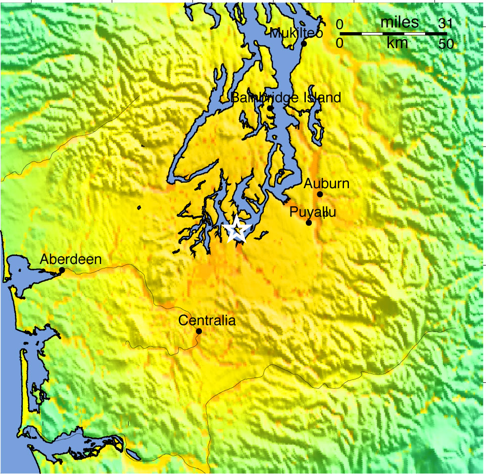
OLYMPIA-NISQUALLY FAULT M7.2 EARTHQUAKE SCENARIO
This
scenario models what is considered to be a deep earthquake, like the
2001 M6.8
Nisqually earthquake (see ShakeMap below). Unlike the other earthquakes
considered in the Evergreen Exercise, which occur on shallow crustal
faults
within the over-riding North American plate, this type of earthquake
occurs on
a hidden fault deep within the oceanic Juan de Fuca plate.
‘ShakeMap’ showing the
intensity of ground shaking (colors) expected for a M7.2 earthquake on
a buried fault ~32 miles beneath the surface within the subducting Juan
de Fuca plate, overlain on topography. The white star shows the
‘epicenter’, or point on the surface just above where the causative
fault begins to rupture.
Earthquakes often are named for the
nearest impacted, well-known city or town rather than the causative
fault, particularly when the fault has not been mapped (in this case
because it has no clear expression at the surface). These
‘intraplate’
earthquakes
occur
because
the
plate
deforms
as
it
descends,
or subducts, beneath the North America plate. Beneath the
Puget Sound region, deep earthquakes usually occur at depths of about
30 to 50 miles (45 to 80 km) and likely are smaller than M7.5.
These are the most frequent type of damaging earthquake in the Puget
Sound region, having an 84% of occurrence in a 50-year time
period.
Because the faults that break during the
earthquake are so deep, the seismic wave energy they radiate spreads
over a much larger area than in a shallow quake, but the shaking is
much less severe directly above the fault, than in a similar-sized
shallow quake. Notably, unlike crustal earthquakes, deep earthquakes
are accompanied by only a few to no aftershocks. Recent local examples
similar to this scenario event include the 2001 M6.8 (Nisqually), 1965
M6.5, and 1949 M6.8 earthquakes.