The East Java Tsunami of June 3, 1994
The following links provide access to the visual
and quantitative data gathered by the East
Java International Tsunami Survey Team. The overview
section below offers a brief summary of the event. Information
about specific survey sites, including selected digitized images
taken during the 1994 survey, as well as additional images taken
during a 1995 post-event reconnaissance survey, are accessible
through the interactive survey area map.
General Information
- Event Overview: Description of the
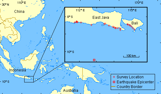
event, including earthquake source information and a locator
map that shows the survey area in a regional context.
- Survey Area Map: An interactive
map that shows the runup distribution and provides links to specific
survey-site data, including selected images taken during the
1994 survey and additional images taken during a 1995 post-event
reconnaissance survey.
Summary Data Tables
- Runup Data: Raw and corrected (for
tides) runup data, presented in tabular form, for all survey
sites.
- Human and Structural Damage Data:
Reported casualties, fatalities, and structural damage data,
in tabular form, for East Java by district and town.
Miscellaneous Information
Event Overview

At 1:18 a.m. Java time, June 3, 1994, a large earthquake occurred
off the southeastern coast of Java near the east end of the Java
Trench in the Indian Ocean. The earthquake, which had a surface-wave
magnitude of 7.2 and a moment magnitude of 7.8, generated a devastating
tsunami that took the lives of more than 200 East Java coastal
residents.
An international tsunami survey team,
composed of tsunami scientists and engineers from Indonesia, Italy,
Japan, Thailand, and the United States, visited the impacted areas
of Bali and Java from June 20 to June 25, 1994. The survey team
observed the most severe tsunami damage along the southern coast
of East Java. Significant earthquake-induced ground shaking was
not experienced by the coastal residents interviewed in Bali and
Java, suggesting that this tsunami may have generated by a tsunami
earthquake. Runup measured along
the southeastern East Java coast ranged from 1-14 m, while runup
measured along the southwestern coast of Bali ranged from 1-5
m.
This account has been adapted from Synolakis
et al.
![[Help]](/tsunami/images/help.gif)
![[Table of Contents]](/tsunami/images/tcarrow.gif)
![[Events]](/tsunami/images/events.gif)

![[Help]](/tsunami/images/help.gif)
![[Table of Contents]](/tsunami/images/tcarrow.gif)
![[Events]](/tsunami/images/events.gif)