![[Help]](/tsunami/images/help.gif)
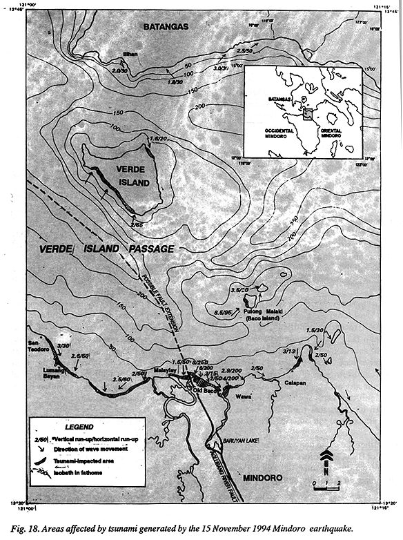
Areas hardest hit by the tsunami are in Barangays Malaylay, Old Baco, Wawa, and Baco Islands where at least 6 meters of vertical run-up was believed to have smashed the shoreline, destroying completely the houses nearshore and leaving at least 41 persons dead, mostly children and old people. All deaths were due to drowning.
The earthquake generated a ground rupture (at least 35-km long) as a result of movement along the recently identified right lateral strike slip fault which trends N10°W. Prof. Kikuchi said that ground rupture propagation from north to south. Although the sense of fault movement is predominantly strike-slip, there might have been significant vertical component near the northern terminus that resulted in displacement of the seabed and generated the tsunami.
The earthquake epicenter was located 11 km N22°W of Baco, Mindoro. Considering a point source from the epicenter, the tsunami wave train propagated radially, hitting the nearby coastal areas in a pattern as shown in Fig. 18. These wave directions were reconstructed based on the still-preserved knocked down palm trees and other vegetation that were directly hit by the waves upon reaching the shores, and the results of interviews with local residents of the affected areas.
The arrival time of waves that hit the various coastal areas could not be exactly reconstructed since most of the respondents gave highly variable answers. Most of the affected inhabitants reacted quickly by leaving their area upon seeing the incoming waves. They were able to rush able rush landward for several tens of meters before the tsunami hit the coastline. Almost all of the respondents living proximal to the origin of the origin of the tsunami reported that not more than 5 minutes lapsed before the first big wave arrived. Majority of the respondents believed that the wave arrived in the order of 3 minutes after the mainshock. Most of the respondents saw the shoreline receding for a considerable distance, about 50 to 100m on shallow foreshore, shortly after the main quake. Then a very audible jet-like or gush of strong rain sound was heard simultaneously with the approaching tsunami.
Some described the as a large curtain-like formation with a dark base and bubbly-white crest at a distance, while others described it as several crests forming a wave train.
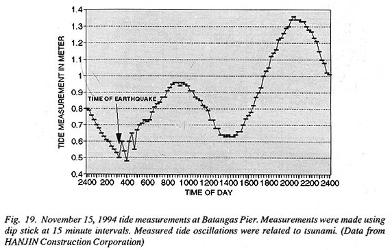
The tsunami wave train formed at least 3 large waves with varying magnitude. Most of the people interviewed claimed that the first wave was the strongest and the succeeding waves were smaller. Figure 19 shows tide measurements conducted at 15-minute interval at Batangas Pier. The tsunami which occurred shortly after the 0315H mainshock was initiated during the lowest tide level of that day. The tide level oscillated for about an hour due to the effect of tsunami as shown in the graph. The impacts could have been aggravated had the tsunami occurred during high tide. The occurrence of tsunami during the lowest tide level exposed several tens of meters of the beach especially on areas of shallow coast and large tidal flats. This helped in dissipating the tsunami vertical and horizontal run-up due to greater frictional resistance.
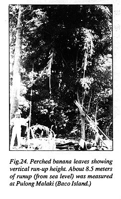
Depending on the submarine and coastal morphology, tsunami waves inundated the coastal areas at varying heights. Table 1 lists the vertical and horizontal run-ups measured at various sites (Fig. 18). In general, higher vertical run-up waves were observed on the coastal areas nearer to the wave origin. Vertical run-ups suggest some correlation with the existing bathymetry. Areas with deeper bathymetry have higher vertical run-up since wave frictional resistance on the coast with deeper foreshore is less, thus energy of arriving waves is still strong. The funneling effect of the trough southwest of Pulong Malaki (Baco Island) enabled the tsunami to attain a vertical run-up of 8.5 meters, the maximum determined run-up height. Horizontal run-up or inundation reached more than 200 meters inland where coastal morphology is flat, e.g., because of the swales and large tidal flats. Fronting Barangays Old Baco and Wawa, horizontal run-up went as far as 250 meters inland.
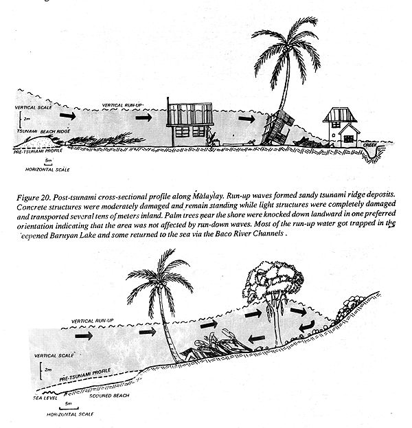
Various morphological features of the coasts have significant effects on the behavior of tsunami. Figures 20 and 21 illustrate this relationship in the case of the Mindoro event.
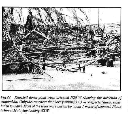
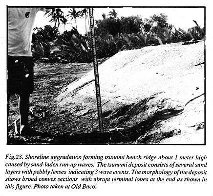
Coast with almost flat topography consisting of bars, lagoons, swales or wide tidal flat experienced only run-up waves with no consequent strong run-down counterparts. The run-up waves knocked down trees towards one direction and this preferred alignment of trees was excellently preserved (Fig. 22). The coastline from Malaylay Island to Wawa has shallow sandy foreshore, and the incoming tsunami scoured much of its sandy sediments and deposited these onshore, forming a tsunami "beach ridge" morphology (Fig. 23).
Tsunami deposits near the shore are thick (more than a meter) and extended landward for about 30 meters. Farther inland, the deposits are significantly thin in the order of a few centimeters to millimeters. This suggests that the entrained sandy materials were highly concentrated at the base of the advancing wave and got deposited immediately when the wave reached the beach zone. The waves that traveled farther inland have less sand concentrations. Tsunami beach ridge deposits are quite extensive, extending for about a kilometer along the coast of Wawa, Old Baco and Malaylay.
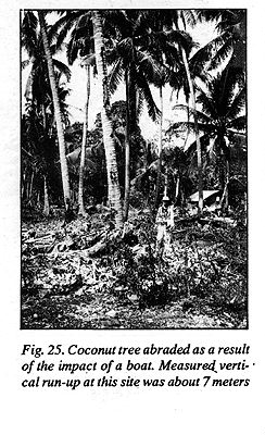
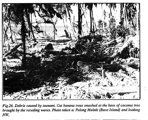
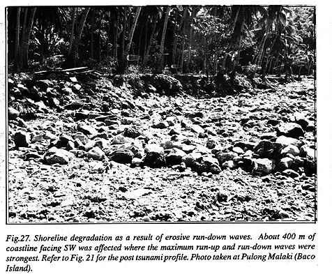
At Pulong Malaki (Baco Island) where the topography of the coast is steeply inclined, the measured 8.5 meter run-up wave (Fig. 24 & Fig. 25) was coupled by strong run-down. As a result, piles of boulders on the hillslope were transported seaward for several meters and the shoreline was also scoured by about 20 meters (Fig. 26 & Fig. 27) by the turbulence of the receding water.
Despite the short lead time, most of the affected residents of the areas hit by the tsunami survived, due, fortunately, to the coincidence of the earthquake with lowest tide level and almost flat topography which prevented run-down in the more populated shorelines.
The people were awakened from their sleep by the strong ground motion and afterward by the strong ground motion and afterward by the strong sound created by the incoming tsunami waves. Most of those who noticed the incoming tsunami were able to run inland and thus escaped the tsunami. A few survivors, mostly strong men, whose homes were hit by the tsunami were able to hold on to something stable. There could have more fatalities if run-up waves were coupled with run-downs which would have transported the victims to the open sea. It was only in Pulong Malaki, (Baco Island) where the tsunami run-up wave was coupled with strong run-down and as a result, one child was carried offshore and remains missing.
There were several fishing boats that were totally destroyed. Damaged houses were mostly built from light structures. Some concrete structures sustained moderate damage even where the vertical run-up waves were higher than the structures. Completely damaged light structures were found along Barangays Wawa, Old Baco and Malaylay.
![[Table of Contents]](/tsunami/images/tcarrow.gif)
![[Recent Events]](/tsunami/images/events.gif)
![[Mindoro]](/tsunami/images/mindoro.gif)
![[Report]](/tsunami/images/report.gif)