Long-term Volume and Annual Mass Balance Studies
Annual mass balance is the net gain or loss of mass of a glacier each year. Mass is gained from snowfall and lost by melting. Winter snow depths typically vary from about 3 m (on the lower glacier) up to 20 m (in the upper cirque). The average daily summer melt rate is about 2.5 cm. Measurements of glacier mass balance are difficult to obtain and are subject to uncertainty. Annual mass balance has not been measured systematically at Blue Glacier, but an estimate has been made for each year from 1956 through 1999. In some years, balance has been estimated from probing of residual snow depths in late September and stake measurements of cumulative ice and firn melt. For 1987-1999, we have estimated annual balance from late season observations of the equilibrium line altitude (ELA), using a regression developed over the years when both ELA and balance were measured.
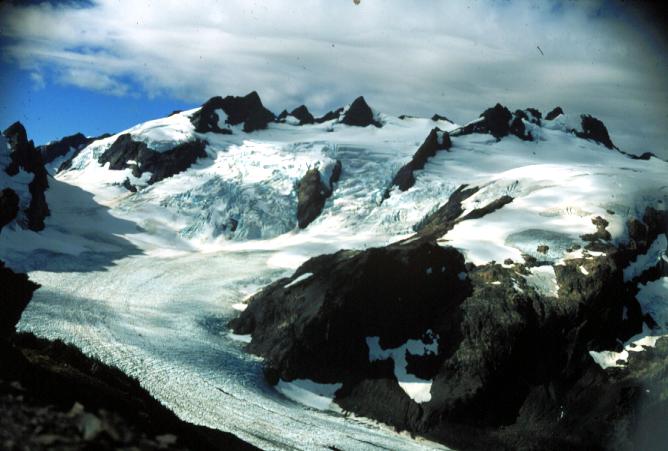
We are investigating the remote monitoring of the seasonal progression of the snowline (and hence glacier mass balance) using a camera that takes sequential photographs through the year from a fixed location. Past measurements on Blue Glacier indicate that there is a good correlation between glacier mass balance and snowline elevation (Conway and others, 1999). Tracking the progression of the snowline allows an estimate of the evolution of mass balance. The net mass balance for the glacier can be estimated from the elevation of the snowline at the end of the melt season. The marked color difference between ice and snow clearly delineates the snowline just below the icefall in this photograph, which is from September 1998. The glacier mass balance at this time, estimated from the average elevation of the snowline (about 1800 m), was -0.37 m water equivalent. Subsequent melt and snowline recession resulted in a very negative mass balance (-1.11 m we) for Blue Glacier in 1998.
Other sources for estimating glacier changes are published and unpublished maps and surveying data. We have maps of surface elevations based on aerial photography taken in 1939, 1952, 1957 and 1987 and we also have theodolite surveying notes of Mark Meier (1957 and 1958) and Keith Echelmeyer (1977 and 1978). During the spring and fall of 1995 we surveyed a few positions on and surrounding the glacier using geodetic quality global positioning (GPS) instruments. The positions, located with respect to the existing network of GPS stations at Neah Bay (Cheeka Peak) and Victoria, BC, are accurate to within a few centimeters. In June 1996, Keith Echelmeyer (University of Alaska) few five profiles along the glacier surface using a light plane equipped with GPS and laser profiling equipment. We have used these measurements to estimate the surface topography of 1 October 1995. This data is discussed in the previous page about surface elevation variations.
Comparison of the mapped surface topographies indicates the mass balance of Blue Glacier has changed less than 7 meters (water equivalent) since 1939 which is minor compared with other glaciers in the world. Further comparison with the map changes shows that the field estimates of annual balance (1956-1997 mass balance) are too positive by about 0.4 m/a, indicating that considerable caution is needed when interpreting time series of mass balance (Conway and others, 1999).
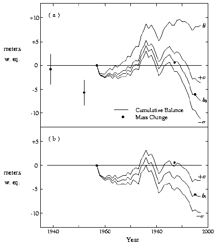
Plot shows cumulative specific mass balances (annual resolution) and specific mass changes relative to October 1957, in water-equivalent meters.
(a) Cumulative mass balances b' and adjusted b2 with standard error.
(b) Cumulative adjusted mass balance b1 with standard error.
Source: Conway and others (1999, Figure 3)